 in the map Navigator
 . When you choose
to see lease data in table form, lease data will be displayed as follows:
. When you choose
to see lease data in table form, lease data will be displayed as follows:To go from map view to table view, click the Table View button in the map Navigator. When you choose
to see lease data in table form, lease data will be displayed as follows:
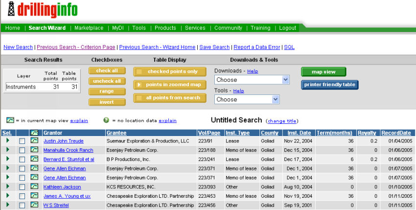
Clicking on the linked Grantor name will take you to the details about the lease or other real property instrument.
Note: The Grantor in some cases will be an operator who is granting lease rights back to the mineral owner (release of lease). In other words, a transaction between a Grantor and Grantee is not always a new lease.
Note: A zero value for royalty may indicate a memorandum of lease (in which the Grantor and/or Grantee wish not to disclose either term or royalty information), a release of lease, or other non-lease instrument.
The term of the lease refers to either the period of time the lease will be in effect (paid-up lease), or the period of time that the lease will remain valid as long as periodic payments are made (delay rental lease). The term shown is with respect to the date of execution of the lease rather than today’s date.
To convert from table view to map view, click on the Map View link. To print the table, click on the Printer Friendly Table link.
Under Checkboxes you can use the buttons to check all, uncheck all, select a range of results by selecting a beginning point and an ending point and then clicking range, and the invert button will reverse the selection.
The Table Display buttons will allow you to view only the checked points, only the points visible on the map or all points from the search.
The Downloads menu will allow you to chose several options for exporting the data, including:
Contour(.dcf) - Allows you to export the data directly into DI Surf
CSV This Table - Opens the Table View up in Microsoft Excel
CSV This Table (Zipped) - Exports the data in Table View to the Microsoft Excel on your system
Lat/Longs for Checked Points - Downloads the lat/longs for the selected wells into two new columns in Table View
The Tools menu contains:
Convert Coordinates - Allows you to convert already downloaded lat/longs to a different projection (For example, from NAD 27 to State Planes or NAD 83)
See Table Help for more information on displaying and sorting results.