
Different methods to get Lat/Longs for a point:
Method 1: View the permit detail. If the permit has an associated lat/long it will be visible at the very bottom of the page.
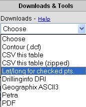
Method 2: Use the "Lat/Long for Checked Points" option in the Downloads drop down menu in the Table View to get lat/longs for the wells you have checked.
NOTE: Lat/Long downloads count against your Account or User quota.
Method 3: On the production chart (assuming it produced), download the production (as a CSV file) by clicking on either of the DRI links listed. This will include the monthly production, header information and the Lat?long. (Use the DRI File Spec sheet to decipher the download format.)

NOTE: Multiple production stream downloads count against your Account/User quota. Single downloads do not.
Method 4: Download the map as a DXF file from the Map View. Assuming you zoom up enough, the API will be rendered for each well. You can then open the DXF and get the lat/long using any CAD/GIS program.

Method 5: Use the "Find Lat/Long" feature
under Tools in the Map View. Click on the  button and then click the point on the map
for which you want a lat/long.
button and then click the point on the map
for which you want a lat/long.
For further information, see Table Data Download.
For further information about Quotas, see Help with Quotas.